Bar nearby Taperia Daniel
Spain
Bar nearby Taperia Daniel
Taperia Daniel
Calle de Gutenberg, 10, Madrid España
contacts phone
:
+34
Latitude:
40.4052748
, Longitude:
-3.6809834
read more
nearest Bar
23 m
La Esquina De Daniel
Calle de Gutenberg, 8, Madrid
Bar
read more
96 m
Cafetería la Parisiena. Donde Cris
Calle de Granada, 7, Madrid
Bar
read more
147 m
Bar On Rock
Avenida de la Ciudad de Barcelona, 5, Madrid
Bar
read more
220 m
La Riberuca del Retiro
Avenida de Menéndez Pelayo, 20, Madrid
Bar
read more
294 m
Sidreria Astur
Calle de Valderribas, 23, Madrid
Bar
read more
303 m
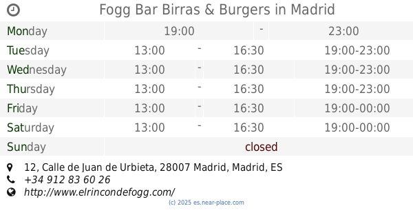
Fogg Bar Birras & Burgers
Calle de Juan de Urbieta, 12, Madrid
Bar
read more
334 m
Queen's Pub
Spain
Bar
read more
343 m
Bar El Líder
Calle de Cavanilles, 18, Madrid
Bar
read more
377 m
BAR AQUI ME QUEDO
Calle de Juan de Urbieta, 30, Madrid
Bar
read more
380 m
Bar de César
Calle de Juan de Urbieta, 30, Madrid
Bar
read more
416 m
URBAN
Avenida del Mediterráneo, 12, Madrid
Bar
read more
416 m
Bar Castilla - Sr. Djun
Avenida del Mediterráneo, 14, Madrid
Bar
read more
436 m
Cervecería Sagredo
Avenida de la Ciudad de Barcelona, 55, Madrid
Bar
read more
492 m
La Fábrica de la Yaya
Plaza de los Reyes Magos, 6, Madrid
Bar
read more
511 m
MASEDA
Calle Julio Rey Pastor, 4, Madrid
Bar
read more
540 m
Bar La Lonja
Calle de Sánchez Barcaiztegui, 19, Madrid
Bar
read more
669 m
Los Porches
Calle de Méndez Álvaro, 32, Madrid
Bar
read more
804 m
RESTAURANTE LA GLORIA ATOCHA
Paseo de la Infanta Isabel, 5, Madrid
Bar
read more
861 m
El rincon de Victor
Calle Delicias, 38, Madrid
Bar
read more
880 m
100 Montaditos
Plaza del Conde de Casal, 1, Madrid
Bar
read more
895 m
Bar Ancora
Calle del General Lacy, 28, Madrid
Bar
read more
936 m
La Cocina de Payuri
Calle del General Lacy, 38, Madrid
Bar
read more
960 m
Kaiko
Calle de Méndez Álvaro, 14, Madrid
Bar
read more
977 m
Restaurante "Casa Egido"
Calle General Lacy, 50, Madrid
Bar
read more
1.29 km
Bosq
Calle de Tomás Bretón, 54, Madrid
Bar
read more
📑
all categories
Accounting
Administrative area level 1
Administrative area level 2
Airport
Amusement park
Aquarium
Art gallery
Atm
Bakery
Bank
Bar
Beauty salon
Bicycle store
Book store
Bowling alley
Bus station
Cafe
Campground
Car dealer
Car rental
Car repair
Car wash
Casino
Cemetery
Church
City hall
Clothing store
Colloquial area
Convenience store
Country
Courthouse
Dentist
Department store
Doctor
Electrician
Electronics store
Embassy
Establishment
Finance
Fire station
Florist
Food
Funeral home
Furniture store
Gas station
General contractor
Grocery or supermarket
Gym
Hair care
Hardware store
Health
Hindu Temple
Home goods store
Hospital
Insurance agency
Jewelry store
Laundry
Lawyer
Library
Light rail station
Liquor store
Local government office
Locality
Locksmith
Lodging
Meal delivery
Meal takeaway
Mosque
Movie rental
Movie theater
Moving company
Museum
Natural feature
Neighborhood
Night club
Painter
Park
Parking
Pet store
Pharmacy
Physiotherapist
Place of worship
Plumber
Point of interest
Police
Political
Post office
Premise
Real estate agency
Restaurant
Roofing contractor
Route
Rv park, camping
School
Shoe store
Shopping mall
Spa
Stadium
Storage
Store
Subpremise
Subway station
Supermarket
Synagogue
Taxi stand
Train station
Transit station
Travel agency
University
Veterinary care
Zoo
administrative area level 3
administrative area level 4
administrative area level 5
sublocality level 1
↑